Image

By Frank Mariani
https://frankmarianidesign.substack.com/
It’s all just a massive distraction from more important matters, isn’t it? I answer yes and no to that question.
As a kid, I revered maps and mapmaking. When National Geographic magazine arrived in the mail, I’d first go right to the center, pull out the insert, and unfold a masterpiece of storytelling about distant lands. I studied country contours, state borders, coastlines, river paths, mountain ranges, and ocean depths.
Thanks for reading Frank's Buffalo Born Babble! Subscribe for free to receive new posts and support my work.
Questions filled my head.
I saw such things as competition between mighty contestants even though the races were long over, save for the incredibly slow pace of erosion and tectonic plate movement.
If you appreciated National Geographic maps as much as I did, you’d enjoy reading about their long history of providing pull-out maps. I had only one complaint about them: those damned creases! If only they had arrived rolled up in sturdy tubes. *sigh*
DJT can relabel whatever he wants because it won’t stick in my brain, where National Geographic’s skilled cartographers imprinted the world’s layout long ago.
There are pros and cons to taking that stance, however. I will always see the Gulf of Mexico, Greenland, and all the Canadian provinces the way I was taught. But part of me is still looking for Yugoslavia!
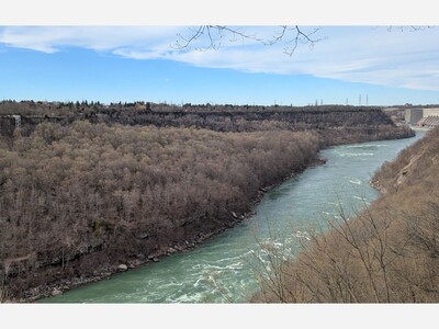
Took a hike from Whirlpool earlier in the week, first time down and up those steps. It was definitely leg day, and I think my Mutt qualified as a service dog dragging me back up!

Heavy rain, with a high of 77 and low of 50 degrees. Don't forget your umbrella! Partly Cloudy in the morning, sunny in the afternoon, fog in the evening, clear overnight.